Missouri River

No results found.

Sorry. Please try using the category links or the search field.

Examination of Omaha’s Annexation History: Scriptown, Saratoga, and Sheelytown

When Omaha (“Omaha City”, as it was then known) was officially incorporated in 1854, it was much, much smaller than its current boundaries. Because the city was being built from hardly anything, the first platting was very precise, dividing the land into 320 blocks exactly 264 feet square.[1] Most streets were 100 feet wide (the only exceptions being Capitol Ave and 21st St., which were 120 feet wide). An inaugural census mandated by the Nebraska Territorial Legislature, completed in November 1854, reported a total of 645 inhabitants within Douglas County. There was no distinction between residents of incorporated or non-incorporated areas, but an estimation has placed the original population of Omaha at approximately 200.[2]

By 1855, another swath of land to the north and west of Omaha City was purchased by the Omaha Land Company, a private company owned by several businessmen who had been involved in the founding of Omaha City. The land was purchased with scrip, the only currency available in Omaha at the time, thus leading to its becoming known as Scriptown. This area encompassed present-day Cuming St. to Fort St., from 16th to 24th, and construction and development progressed quickly. It was incorporated into Omaha in 1877, as the city’s first annexation.

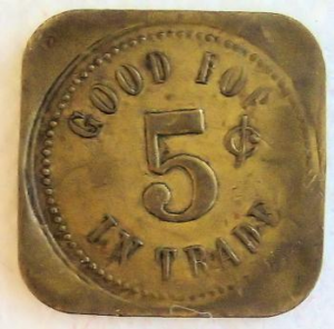
An example of scrip issued by the Omaha City Bank and worth $1. Image courtesy of https://currency.ha.com/itm/obsoletes-by-state/nebraska/omaha-nebraska-territory-omaha-city-bank-and-land-co-1-18-/a/141746-82125.s

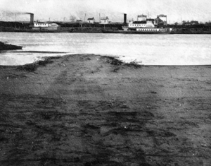
Another town, Saratoga Springs, had been founded the year after Scriptown, in 1856. The official boundaries of this town are listed as Locust St. to Fort St., from Carter Lake to North 36th St., which does raise a question, as there seems to have been some overlap between this space and the northern boundary of Scriptown. In any case, Saratoga Springs was located just three miles north of downtown Omaha, while also being in proximity to Sulphur Spring, whose popularity for health remedies inspired the construction of the Saratoga Springs Hotel. At the time of the town’s founding, it was near the Saratoga Bend on the Missouri River, which saw many steamboat landings. In 1877, however, the Missouri River changed its course almost overnight, creating the body of water that is Carter Lake and cutting the town off from the river.[3] After a few years of stagnation, the city of Omaha annexed Saratoga Springs in 1887.

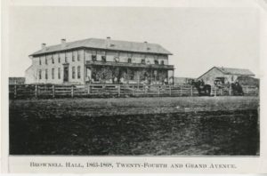
Saratoga Springs Hotel, later known as Brownell Hall. Image courtesy of Douglas County Historical Society.

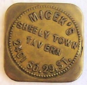
Omaha City grew substantially in 1887, as it expanded to the south as well with the addition of Sheelytown. This was a “town” put up by the Sheely Brothers Packing Houses, owned by Joseph Sheely, for the purpose of housing the many newly-arrived immigrants who worked for the company. The plant was located just southeast of Hanscom Park, and Sheelytown was just south of that, between present-day Edward Creighton Boulevard and Vinton Street, and South 24th and 35th. Its original occupants in the 1860-70s were largely Irish. Soon, both Polish and Czech immigrants began arriving in the area in large numbers, as well.

Token for Micek’s Sheelytown Tavern. Image courtesy of muddobber16 at http://tokencatalog.com/token_record_forms.php?action=DisplayTokenRecord&td_id=342881&inventory_id=321120&attribution_id=350421

Next time, we’ll address the next chronological annexations, which occurred in 1915.

[1] https://en.wikipedia.org/wiki/Timeline_of_Omaha,_Nebraska_history

[2] Hoag, Bertie Bennett. “The Early History of Omaha from 1853 to 1873. Master’s Thesis, University of Nebraska at Omaha. p. 18. 1939.

[3] Becker, H.W. The Forming of Carter Lake. July 1977. Accessed via the Wayback Machine: https://web.archive.org/web/20070923053311/http://www.cityofcarterlake.com/history_forming.html

The Founding of Omaha

The Missouri River corridor and the territory that would become Omaha was a global identity and a profitable business investment as much as four centuries ago! Fur trappers from Europe and the East came for beaver to produce top hats highly desired by the gentry of Europe. One requirement for hiring was that the worker could not swim, a protection that could prevent workers from jumping ship. The fur traders went north only as far as the Mandan Indian Villages in the Dakotas. Lewis and Clark and the Corps of Discovery in 1804 were the first to go beyond.

Territory west of the Missouri River was not open to settlement until after President Franklin Pierce signed the Kansas-Nebraska Act on April 30, 1854. However, prior to that hundreds of adventurers passed through what would become Omaha in search of gold and other riches further west. But Bill Brown in 1850 decided his gold could be found right here, and he established the area’s first ferry business. His Lone Tree Ferry was named for his landing point near the single tree on the western bank. By 1854, when “Omaha City” was founded, his ferries were large enough to transport herds of cattle and wagons. Brown is considered the founder of Omaha because in 1853, a year before it was legal, Native American permitted Brown to quietly stake out a town site of 232 city square blocks for a consortium of businessmen from Kanesville (Council Bluffs). This likely was in appreciation of Bill’s provision of lower fees or spirits for them! Research conducted by the Douglas County Historical Society has determined that Brown’s ferry landing was in the midst of the field of wild flowers bordered by Abbott Drive, Harry A. Trustin Riverfront Drive and Gallup University, a site that today is inland from the Missouri River due to nature and man-made channel changes.

USS Hazard

USS Hazard

Along the Missouri River, Freedom Park sits at 2497 Freedom Park Road. Opened in 1974, it comprises a 12-acre tract of city-owned land near the Greater Omaha Marina. On exhibit are the cold-war era submarine USS Marlin (SST-2), Douglas A-4C Skyhawk, and LTV A-7D Consair II. An anchor and propeller garden exist along with shipboard rocket launchers. The parks major feature, however, is the USS Hazard (AM-240), the only Admiral-class minesweeper in the United States.
The USS Hazard served the United States Navy during World War II. The Navy commissioned the ship that carried a 104-member crew on December 30, 1944. The minesweeper is 184 ½-feet long and 33-feet wide, weighing 950-tons. The crew’s former mess hall today is a museum where a large collection of photos with numerous weapons and munitions carried on the ship are available for public viewing. It also contains quartermaster logbooks, blueprints, and a radio room that plays 1940s music.
The minesweeper’s first mission was to perform escorts from San Diego, California to Hawaii. Later, it swept waters off the Kerama Retto Island group, fifteen miles west of Okinawa. At the war’s end, the ship cleared waters off Korea and Japan for occupation forces. The ships motto was, “Where the fleet goes, we’ve been.” The Hazard earned three battle stars for WW II service. Decommissioned by the Navy in 1946, the ship rested in Orange, Texas’ naval yard.
The ship’s logs showed that the World War II crew was disorderly. The shore patrol arrested three-crew members in Oakland, California for having the Central Bank, Oakland’s brass nameplate. The shore patrol arrested another crewmember for, “throwing and breaking glasses on the floor of the Congo Club,” in Galveston, Texas while people danced. They arrested the same man later when he tried to bring a lawn chair into the same club. Other reports show many crewmember offences of drunkenness, public urination on sidewalks, and interfering with women working as shipyard employees.
A group of Omaha and Houston business people formed the USS Hazard Corporation that negotiated USS Hazard’s sale. They outbid the Mexican and Portuguese governments for the minesweeper. They purchased the ship and paid to have it towed up the Mississippi and Missouri Rivers in 1974 on a barge. Three state governors agreed to open large river dams to release enough water to float the ship in river waters in 1971. It took 29 days for the ship to arrive in Omaha, making the 2,000-mile trip from Orange, Texas at a speed of 100 miles per day. Crewmembers thought the Hazard lucky because the ship never received battle damage. Most operating systems are still functional.
The Hazard’s sister ship, the USS Inaugural (AM-242), went to St. Louis, Missouri to serve as a museum, but was destroyed on August 1, 1993 by flooding that ripped the USS Inaugural from its moorings. After floating down the river, it banged into the Poplar Street Bridge. The boat was rescued and lashed to a barge south of the MacArthur Bridge. Two months later on September 23, 1993, it rolled to port and sank. The ship’s remnants emerges with the Mississippi River runs low.
The USS Hazard suffered setbacks due to flooding in 2011 when the Missouri River crested at 36 feet. Engineers feared that the vessel would shake free, float down the Missouri, and take down the Bob Kerry Pedestrian Bridge. They anchored the minesweeper to keep it in place while floodwaters floated in. When the water receded, the ship leaned to its side. After volunteers restored the minesweeper, it reopened in 2015. Freedom Park closed again in 2019 because of flooding. Today, it remains closed.
In Freedom Park, the USS Hazard rests. The minesweeper served the Navy during World War II along with its sister ship, the USS Inaugural. After the war, the Navy decommissioned the ship. The USS Hazard Corp bought and shipped the minesweeper up the Mississippi and Missouri Rivers to Omaha, Nebraska. After floodwaters destroyed the USS Inaugural, the USS Hazard became the only admiral class submarine in the United States. Although Freedom Park is closed, the USS Hazard is still one of the gems in Omaha.

Bob Nandell, “The Unsinkable USS Hazard” (8 August 1982), The Des Moines Register, pg. 251.
https://www.newspapers.com/image/131771535/?terms=%22USS%2BHazard%22
Ibid.
Brooke Criswell, “Shipshape After Repairs, It’s Open to Public Again” (11 October 2015), pg. 11.
“Grand Opening at Freedom Park U.S.S. Marlin” (22 August 1974), Omaha World-Herald, pg. 28.
“Decommissioned U>S. Navy Minesweeper Is Purchased” (9 April 1971), The Lincoln Star, pg. 22.
https://www.newspapers.com/image/311209145/?terms=USS%2BHazard
Robert McMorris, “A Jolly Crew” (12 April 1971), Omaha World-Herald, pg. 5.
“Decommissioned U>S. Navy Minesweeper Is Purchased.”
AP, “Ship Renovator Recalls Plight of USS Hazard” (21 October 1981), pg. 27.
https://www.newspapers.com/image/350397692/?terms=USS%2BHazard
“Minesweeper Being Towed Up Missouri” (31 May 1971), St. Joseph News-Press, St. Joseph, Missouri, pg. 15.
https://www.newspapers.com/image/561765704/?terms=USS%2BHazard
Bob Nandell.
“World War II Mine Sweeper Tied Up Permanently at Omaha’s Riverside” (14 May 1988), pg. 7.
https://www.newspapers.com/image/311577977/?terms=%22USS%2BHazard%22
Tim O’Neil, “WWII Craft Rides St. Louis Levee, Sinks Like Riverboat” (25 November 2012), St. Louis Post-Dispatch, St. Louis, Missouri, pg. B003. https://www.newspapers.com/image/150736260/?terms=%22USS%2BInaugural%22
Connie White, “Flooding on Bluffs Side Shuts Down Bob Kerrey Pedestrian Bridge” (15 March 2019), Omaha World-Herald, pg. 4A.
Brian Mastre, “The Future of Freedom Park” (27 October 2014), 6 News On Your Side, accessed on 16 January 2020. https://www.wowt.com/home/headlines/The-Future-of-Freedom-Park-280574192.html

Close filters
Products Search
Products Price Filter